Newport’s Creation Myth
Countless Rhode Island historical writings, from ancient publications to modern work, present the founding of Newport as an almost mystical event. As the common narrative goes, nine wealthy families who are wholly disgruntled with the way things are going on the Northern end of Aquidneck Island, pack their bags and travel South through virgin forest and arrive miraculously at Newport harbor in the Spring of 1639, where they set themselves up, declare that the “plantation be called Newport,” and launch a thriving society and government that subsequently influences the commercial and ideological course of America. Even today’s official seal of the City of Newport and numerous signs on the island inaccurately proclaim, “SETTLED 1639.” While Newport was founded in 1639, as a settled physical place, named town, and social and commercial ideal, Newport existed well before this as seen in period cartography, Dutch manuscripts, the writings of Roger Williams and John Winthrop, and original Aquidneck records.
Early Cartography
It was no secret that an excellent harbor existed at the Southern end of Aquidneck. Adriaen Block, after determining that Manhattan was, in fact, an island, proceeded East and contributed to a map in 1614 of Long Island Sound and Narragansett Bay. As Block’s map was based, in part, on the work of prior cartographers, combined with his new first-hand knowledge – which is shaded in green – some things are presented more accurately than others. Block clearly shows what is now Point Judith and Narragansett Bay, in which the first large island on the Western side is Jamestown, shown without Dutch island. The next is Aquidneck, with the unmistakable shape of Newport harbor on its Southwestern shore. It is to the East of Aquidneck that things get somewhat skewed in Block’s presentation. The Sakonnet River clearly extends up and connects with upper Narragansett Bay, but the Elizabeth Islands are drawn as a cluster that project out of Narragansett Bay rather than Buzzard’s Bay. Notable is Block’s notation of “sloupbay” which is now called the West Passage of Narragansett Bay (link). At the time, there was already a functioning trading post there called Quotenis (“Quetenesse”), which is now called Dutch Island, and trading also likely occurred along the Pequot path near Wickford where Richard Smith established his trading post at Comcumcussoc. Willem Blaeu’s 1635 map of the region draws heavily on Block, he also notes “Chaloop Bay,” puts Dutch Island in its proper place, gives Newport the name “Anckerbay” and names “Bay van Nassouwe” at the head of an apparently combined Narragansett and Buzzards bays. The “Nassau” on the older Dutch charts is applied broadly to Narragansett Bay and Buzzard’s Bay and their various rivers. The name was chosen because, at the time of Block’s map, Maurice of Orange-Nassau led the Dutch republic. Writing in 1625-1630, cartographer Johan de Laet describes sailing from Martha’s Vineyard (“Texel”) to Block Island where, at mid-journey, to the North is “situated first the river or bay of Nassau which extends from the above named Block’s Island northeast by east and southwest by west. This bay or river of Nassau is very large and wide, and according to the description of Captain Block is full two leagues in width….From the westerly passage into this bay of Nassau to the most southeastern entrance of Anchor Bay…our countrymen have given to names to this bay, as it has an island in the center and discharges into the sea by two mouths, the most easterly of which they call Anchor Bay and the most westerly Sloop Bay.” In this context, “Nassau” is Buzzard’s Bay, but others appear to ascribe the Sakonnet River to Nassau as well. That leaves de Laet’s description of Anchor Bay as the East Passage with Newport harbor and Sloop’s Bay as the West Passage with Dutch Island. This concept is reinforced by a letter from Isaack de Rasieres to Samuel Blommaert written around 1628 describing his arrival in New Netherland in July 1626 and a visit to Plymouth in October 1627. De Rasieres says that “coming out of the river Nassau, you sail east-and-by-north about fourteen leagues along the coast, a half mile from the shoure, and you then compe to ‘Frenchman’s Point’ at a small river where those of the Patucxet have a house made of hewn oak planks, called Aptucxet….here also they have built a shallop in order to go and look after the trade in sewan, in Sloup’s Bay and thereabouts, because they are aafraid to pass Cape Mallabaer…” (source) De Rasieres is describing the correct distance in nautical miles of a trip out of the Sakonnet River, then left and up to the head of Buzzard’s Bay to Bourne on the Manamet River, where a trading post existed (and exists today as the Aptucxet trading post museum) to avoid a journey outside Cape Cod (“Mallabaer”). That Sloup’s Bay is mentioned distinctly implies that the trading would therefore go from Aptucxet past the Sakonnet towards Newport and Dutch Island.
Early Trading
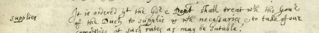
By 1637, the same year that the Aquidneck deed was written, the Dutch had already been actively trading in Narragansett Bay for years, even before the settlement of Manhattan. Dutch Island was (and is) and excellent harbor and its advantage over Newport was its closer proximity to the mainland’s Narragansett fur trade. Aquidneck’s mainland access was on the Sakonnet side, but the Sakonnet offered no ideal harbor, so Newport harbor was the likely nexus of Aquidneck trading – which was less robust than the mainland’s fur supply. The Dutch were so focused on this Narragansett trade that, in February 1651, Petrus Stuyvesant argued the New Netherland boundary claims included “therein Long Island, situate right in front of New Netherland, whence it is separated by an arm of the sea, called the East river, which begins at Coney Island, in the North bay of the North river, and runs again into the sea at the eastward, near Fisher’s Island, opposite the Pequatoos river, together with all other bays, rivers and islands situate westward of Cape Cod, and especially the island named Quetenis, lying in Sloop bay, which was purchased, paid for and taken possession of in the year 1637, on the Company’s account.” (link) Notable is Stuyvesant’s choice of the word “especially.” Coastal traders between Plymouth and New Netherland were certainly aware of, and likely used, Newport harbor, as did local trade occurring between these two commercial centers. As an example, in 1649, Roger Williams wrote from his Narragansett post to John Winthrop in Boston: “For preface, this Mr. Smith’s pinnace (that rode here at your being with us) went forth the same morning to Newport, bound for Block Island, and Long Island, and Nayantick for corn; with them went a Narragansett man, Cuttaquene, a usual travel for Mr. Smith: the wind being (after three or four days stay at Newport) northeast and strong, they put into your river and so to Mohegan.” Richard Smith’s neighbor on “Sloop’s Bay” was Roger Williams, and his neighbor on Manhattan was Isaac Allerton, who was in New Amsterdam by 1636 and likely stopped in Newport on his voyages. Allerton traded as far as the Caribbean and knew the importance of Narragansett Bay because, with William Bradford, they worded the patent of 1629/30 to state that the boundary of Plymouth encompassed all of Narragansett Bay. Isaack de Raisiers’ introduces William Bradford to sewan/wampum in trade when he writes that “the seeking after sewan by them is prejudicial to us, inasmuch as they would, by so doing, discover the trade in furs; which if they were to find out, it would be a great trouble for us to maintain.” (source) The source of sewan, from quahog shells, were the Narragansetts and Pequots in Narragansett Bay and Eastern Long Island Sound, respectively.
Early Naming Conventions
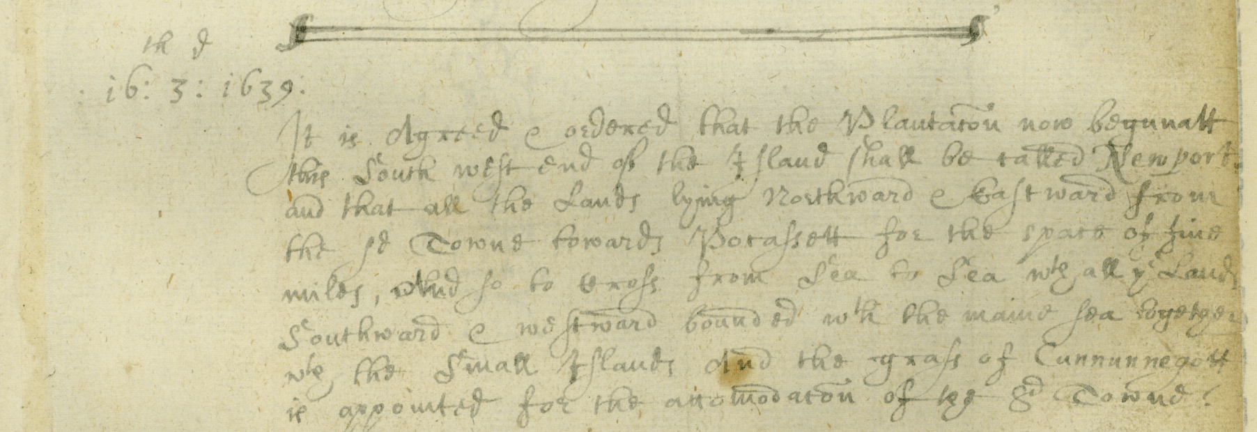
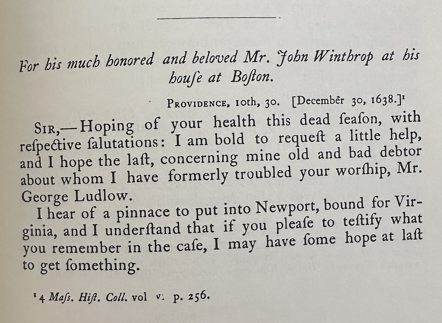
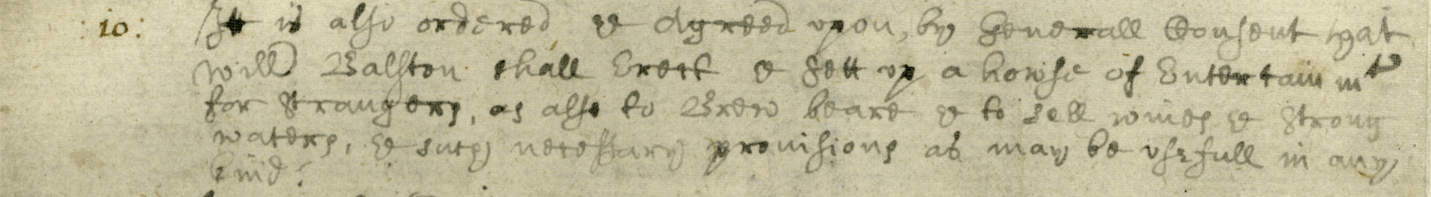
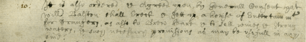
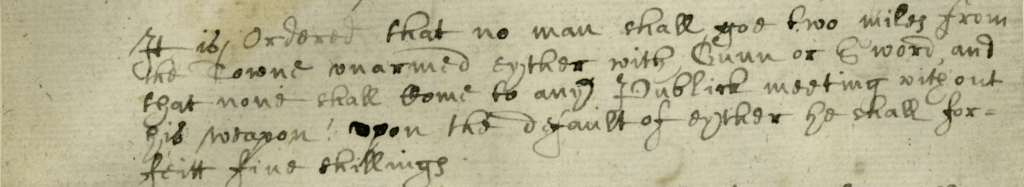
Howard Chapin, in his “Documentary History of Rhode Island” (V1, pg 40) mistakenly writes that “As early as the year 1636 the name Rhode Island was applied to Aquidneck, as is shown by the letter of Roger Williams to Deputy Governor John Winthrop, which from its context was evidently written in the late summer or early autumn of 1636, and dated at New Providence. It reads: They also conceive it easy for the English, that the provisions and munition first arrive at Aquednetick, called by us Rode-Island, at the Nanhiggontick’s mouth.” The letter in question was actually written in May 1637 and this use of “Rhode Island” predates the formal Aquidneck record of March 13, 1644. Similarly, Newport was a distinctly named place well before the formal naming and founding of the town on June 16, 1639 when it was determined that the new “plantation be called Newport.” A full year earlier, on the May 1638 list of Aquidneck inhabitants, there were 42 under the heading “Inhabitants admitted at the Town of Nieu-Port.” Notably, the document says “the Town of Nieu-Port” not simply a simple descriptive as “the new port.” A town is a distinct collection of people that reside together. In August 1638, Roger Williams, writing to John Winthrop, referred to the inhabitants of Aquidneck as “the islanders” and not something more specific such as “the people of Pocasset” and this broader term would appear to encompass both Pocasset and Newport. Later, in a letter from Roger Williams to John Winthrop on December 30, 1638, Roger says “I hear of a pinnace to put into Newport, bound for Virginia…” This is the first use of “Newport” in Roger’s writings. A boat that stops in Newport before sailing south is likely provisioning, which requires the support of people ashore to provide the requisite goods and services, particularly before the presence of docks and wharfs. Clearly, Newport was a named place inhabited by many people before Coddington’s company arrived and formalized the name and government in 1639.
Aquidneck Population Movement
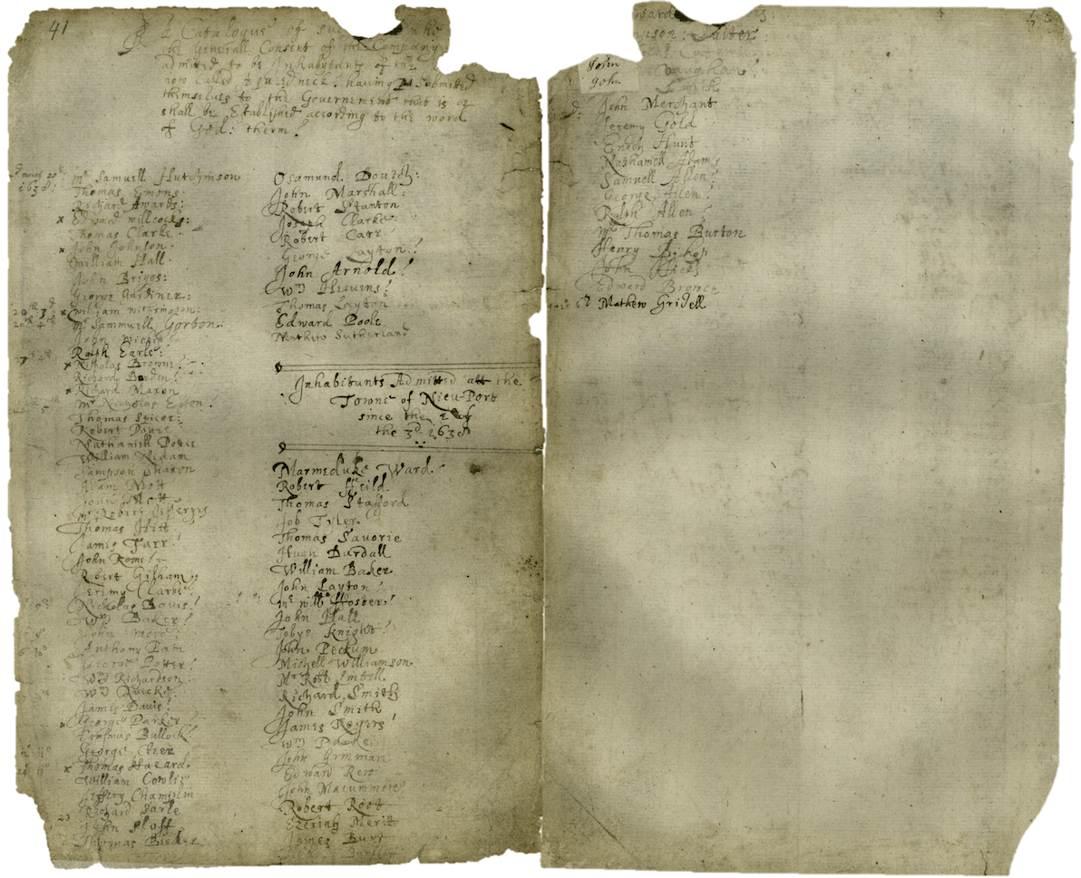
Perhaps the most important, yet overlooked, document regarding the history of Aquidneck Island is the May 20, 1638 list of Aquidneck male inhabitants. I have not seen this analyzed in any historical writing on Rhode Island, yet it is instrumental in understanding Newport’s history.
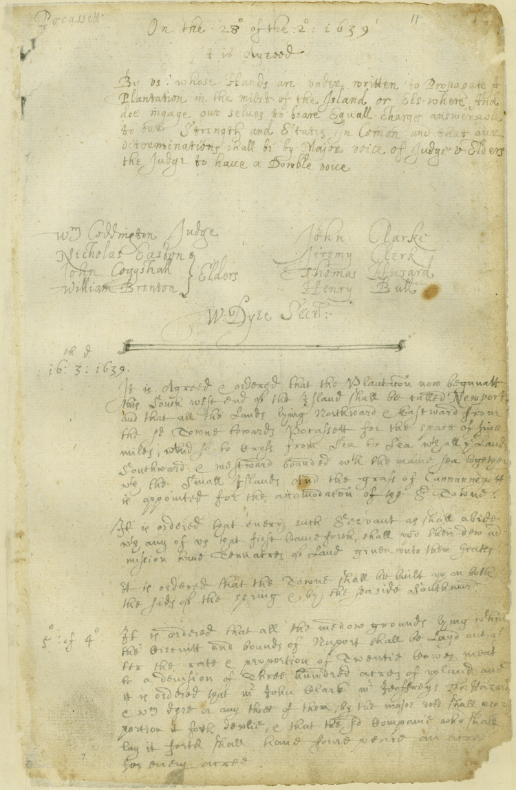
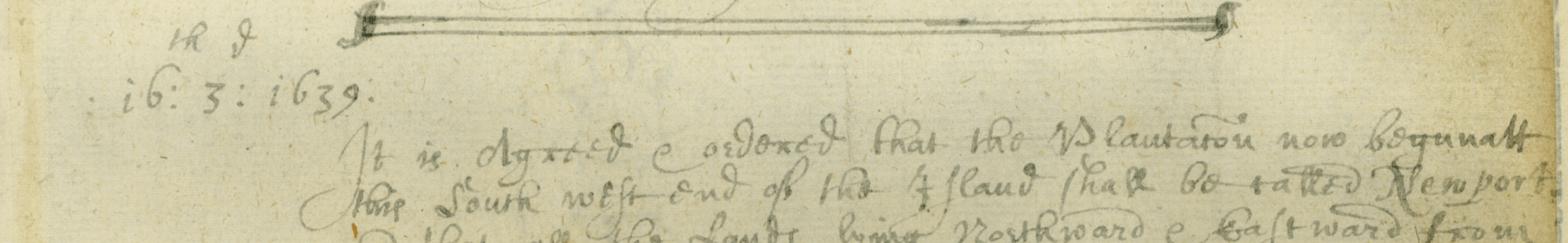
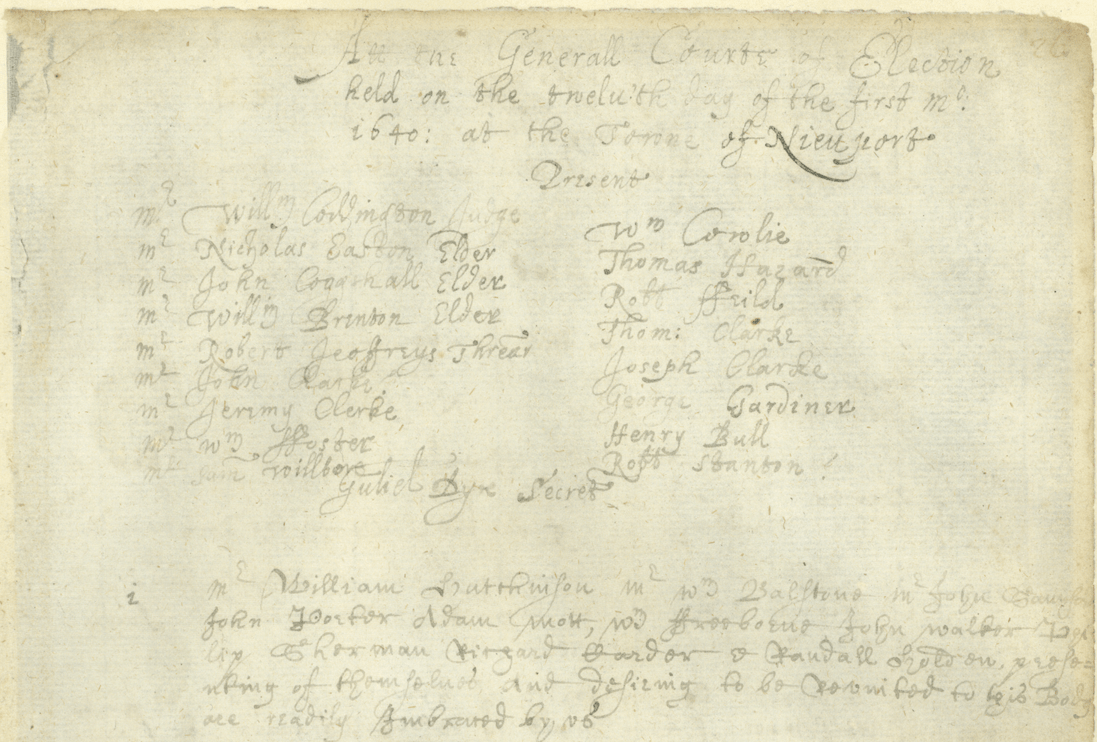
The heading at the top of the manuscript says “A catalogue of such who, by the Generall consent of the Company were admitted to be Inhabytants of the Island now called Aqueedneck, having submitted themselves to the Government that is or shall be established according to the word of God therein.” This is followed by a subheading, “Inhabitants admitted at the Town of Nieu-Port.” Therefore, it can be presumed that the first list refers to residents of Pocasset. The Pocasset list contains 58 names, and the Newport list contains 42 names. This is only two months after the signing of the compact. Clearly, people didn’t linger around the cove and town pond at the Northern end of the island. Pocaasset had an enormous amount of religious and social drama. People immediately moved south and, however crudely, built lodgings in Newport. They were “inhabitants” which means they truly lived there, as settlers. This is a nearly a year before the separation from the Pocasset plantation on April 28, 1639 to “propagate a new plantation in the midst of the island“ by William Coddington, Nicholas Easton, John Coggeshall, William Brenton, John Clarke, Jeremy Clark, Thomas Hazard, Henry Bull, and William Dyre. These 42 residents were also living in the named town of “Newport” exactly a year before Coddington and company decided on June 16, 1639, that their new “Plantation be called Newport.” Shortly thereafter, Portsmouth was made the official name of the Northern settlement on July 1, 1639.
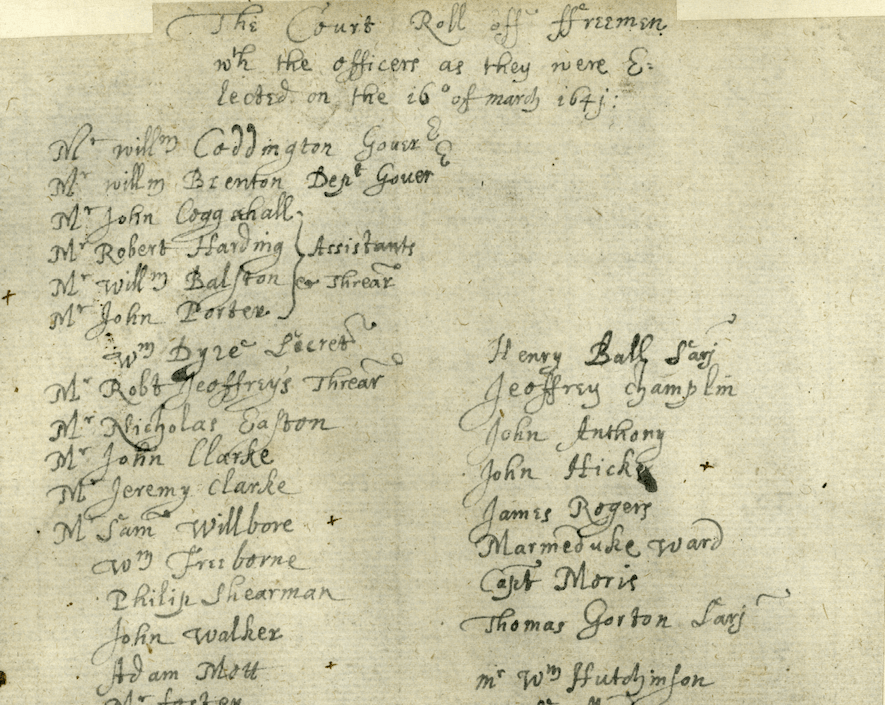
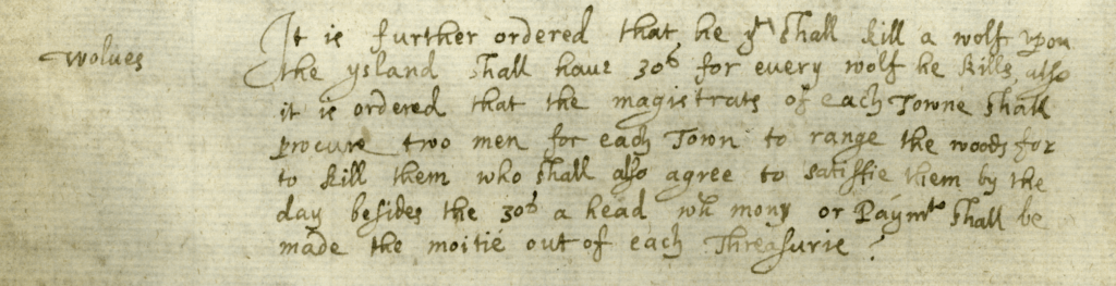
The Newport founding mythology was supported by Peter Easton’s writing, in 1669, about his experience in 1639: “In the beginning of May this year the Easton’s came to Newport in Road Island and builded there the first English building and they planted this year and coming by boat they lodged at the island called coasters harbor the last of Aprill 1639 and the first of May in the morning gave that island the name of coasters harbor and from thence came to Newport the same Day.” From an architectural perspective, this may have been the first “English” style building, but it was certainly not the first building or dwelling. That 42% – nearly half – of the island population was already living in Newport within two months of the foundational signing of the Aquidneck compact is significant. Not one of the future Newport “founders” are on the 1638 Newport list, while the Pocasset list includes Nicholas Easton, Jeremy Clark and Thomas Hazard. Missing from both lists are Coddington, Brenton, Bull and Dyre. Also missing are some of the Aquidneck compact signers. Perhaps the preamble to the list – “having submitted themselves to the Government that is or shall be established” by default includes those already named to the government which, at the Pocasset General Meeting on May 20, 1638, included: Coddington, Hutchison, Coggeshall, Baulston, Sanford, Wilbore, Porter, Freeborne, Walker, Shearman, and Dyre. Nevertheless, the “founders” are not on the Newport side of the ledger and, astoundingly, there are only seven people on the May 1638 Newport list that also show up in the 1655 list of Newport freemen. And one of them, William Baker, moved back to Portsmouth – as did William Brenton and Thomas Hazard. A further five from the 1638 Pocasset list were on the 1655 Newport list: Jeffery Champlin, Joseph Clarke, Robert Carr, Robert Stanton, and Nicholas Easton. Of the original Aquidneck compact signers, five were on the 1655 Newport list: Henry Bull, John Clarke, John Coggeshall, Thomas Clarke, William Coddington. There were seventeen years between the 1638 compact and the 1655 freemen list, and much changed in personal lives and the colonies during that time. Richard Smith is a case in point, having been on the initial Newport list before moving on to Portsmouth, Manhattan, and Cocomcussoc. The other 41 original Newport settlers were also pursuing various vocations and dealing with unique family circumstances – more in the spirit of land use as conceived by the Narragansetts. They were also probably less interested in the new theocracy. However, the settlers’ presence on the island, and in Newport, was also highly influenced by land ownership – and Coddington and his wealthy friends controlled everything. Both, however, knew what a good harbor and active port could do for trade, and realized that Newport was to Portsmouth as Boston was to Plymouth.
Aquidneck Acquisition & Social Implications
There would be no Aquidneck had Roger Williams not suggested it to Coddington or negotiated on the behalf of the Boston exiles. Williams had a vastly different attitude toward Indian lands than all other settlers. The March 24, 1637 deed to Aquidneck was viewed as an outright English legal sale by Coddington, but a right-of-use by Williams and the Narragansetts. The deed itself, witnessed and signed by Williams, said:
“we Cannonnicus and Miantunnomu ye two cheife Sachims of the Narihigansets, by vertue of our generall Command of this Bay, as allso the particular subjecting of ye dead Sachims of Acquednick & Kitackamuckqut, themselves and Lands unto us, have sold unto Mr Coddington and his friends united unto him, the great Island of Acquidneck lying from hence Eastward in this Bay,as allso the Marsh or grasse upon Quinunnagut and the rest of the Islands in this Bay (excepting Chibachuwesa formerly sold unto Mr Winthrop, the now Govr of ye Massachusets, and Mr Williams of Providence) allso the grasse upon the rivers and Coves about Kitackamuckqut, and from thence to Paupasquatah, for the full payment of forty fathom of white beades, to be equally devided between us.”
Just a year later, in June 1638, a few months after the Aquidneck compact was signed, Williams wrote to Winthrop strongly stating that Coddington did not “own” the island in the English sense:
“Sir, concerning the islands of Prudence and (Patmos, if some had not hindered) Aquednick, be pleased to understand your great mistake: neither of them were sold properly, for a thousand fathom would not have bought either, by strangers. The truth is, not a penny was demanded for either, and what was paid was only gratuity, though I choose, for better assurance and form, to call it a sale.”
Regardless, land allocations proceeded on Aquidneck, first at Pocasset and then in Newport. The acreage granted generally matched social standing, particularly in Newport. Those that had earlier settled Newport by 1638 were necessarily displaced by the grants to the nine founding members as only 7 of the 42 on the May 1638 list were on the 1655 Newport list.

 Philip Shearman 1611-1687
 stood until 1973, amongst the oldest houses in the state. After Portsmouth and Newport joined, Adam appears at the General Court in March 1642 where, in consideration of the formation of militia for Aquidneck, he is elected as the clerk of the Portsmouth militia, responsible among other things for the the “Traine Bands” to be exercised monthly. Adam’s father, John, also came to Portsmouth and he was supported by the town. On June 9, 1652, the town “agreed that there shall be a stone house built for the more comfortable being of old John Mott in the winter” and on January 23, 1655 it was agreed that “the town will be at the charge to pay old man John Mott’s passage to Barbades Island and back again if he cannot be received there, if he lives to it, if the ship owners will carry him.” John survived, for he shows up on Aquidneck subsequently in 1655-1656. Adam was likely a follower of Anne Hutchinson as a Massachusetts constable’s detachment went to seize him on September 6, 1638, but he had already fled the colony. Adam’s 1661 will named “my faithfull friends Edward Thurston and Richard Tew both of Newport on Rhoad Iland” as executors. His estate was left to his wife, and included his “house and land, four oxen, five cows, a bull, a horse, one mare, a colt, two calves, thirty ewe sheep, two rams, six swine, 3 pounds in wampum peage, clothes, books, two feather beds, two flock beds, six pewter platters, a wine pot, warming pan, seven pair of sheets, six napkins, two tables, a joint stool, and one and one-half acres of wheat, two acres of oats, two acres of peas, and three acres of Indian corn.” His son, Adam (1623-1712), from his widow Elizabeth, married his stepsister, Mary Lott, Sarah’s daughter, who also sailed on the DEFENCE.


