John Rathbun
1628-1702
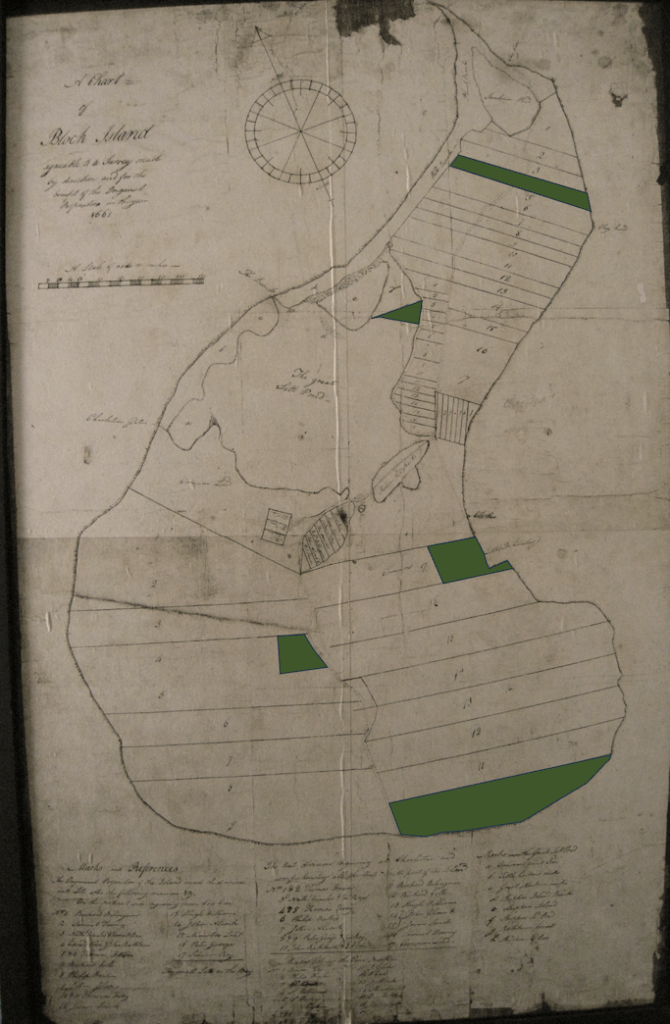
As one of the original purchasers and settlers of Block Island, John stepped onto the beach on the northern end of the island in April 1661, having sailed down from Taunton. The 16 proprietors allocated land amongst themselves in various parts of the island. Rathbun land is shaded in green in the map below. In the northern part of the island, John and his partner, Edward Morse, were given Lot 4 and in the southeastern part of the island they were given Lot 10. Lot 4 lies on the northern neck south of Sachem Pond running across the island from between Balls North Point and Clay Head in the east to Middle Pond in the west, and Lot 10 which was the entire southeastern coast from Barlow’s Point and what is now Lakeside Drive extending east along Mohegan Trail to just north of Southeast Point. Allocations were also given in the middle of the island around the pond and the town of New Shoreham. In the Rhode Island Land Evidences, he shows up in October 1671 with Vose contesting a misallocation in the original allocation, for which they were given additional land, which shows in the map below as the shaded area on the Eastern side of the island where, today, the town of New Shoreham sits at Old Harbor. Also shown is a triangular piece of land on the Great Salt Pond, which is today under water. In total, he owned over 530 acres.

John first appears in the records of the General Assembly for the Colony of Rhode Island and Providence Plantations on May 4, 1664, in Newport, with other Block Islanders, when they are made freeman of the colony: “in behalfe of…John Rawsbone… inhabitants and house keepers at Block Island afore mentioned; desireing that the forementioned inhabitants may be admitted freemen of this Collony.” He later appears as a representative of Block Island in the General Assembly on May 3, 1681, in Newport; May 2, 1683, in Newport; and May 6, 1684, in Newport. He appeared on a grand jury September 1, 1688, in Rochester. He was also a signatory, on July 16, 1686, to the colony’s support of King James II. In 1689, he had a run-in with pirates on Block Island.
William Brenton, in his will dated February 9, 1674, bequeathed to his son Jahleel “all my two farms at Hammersmith and marsh and upland at Newport Neck” which, dated previously in an inventory on August 20, 1674, included “my farms and houses at Hammersmith in possession of John Rathbone and lands thereunto belonging, 2600 pounds.” At this time, Hammersmith – the name of William’s home in England – included 2,000 acres of all the land between what is now Brenton Point and Fort Adams. Brenton’s inventory also included “my houses, lands and wharf in Newport Town.” He gave his livestock to “Mr. Roger Williams of Providence” and gave his son-in-law Peleg Sanford “all my right in Elizabeth’s Island and all the debts due to me in the Island of Barbados.” Brenton owned the largest flocks in New England, and the Hammersmith farm had 1,613 sheep at the time of his death. Before Hammersmith came into Brenton’s possession, it was shipping cattle and corn to Barbados by at least 1649. John and Margaret were likely living on William Breton’s land in 1672 when their son, Samuel, was born on August 3. Samuel’s connection to Newport was strong – in 1692, he married Patience Coggeshall, granddaughter of Portsmouth and Newport founder John Coggeshall. Samuel’s birth was in the Quaker records, and Margaret was a witness on Block of the wedding of Dr. John Rodman, a noted Quaker from Barbados.
John also had a land transaction with William Allen, a Newport Quaker. In 1641, as drawn by Henry Bull, the “Great Common” was located along the course of a river that ran from what is now Pond Avenue down West Broadway (then Tanner Street) to Marlborough Street and into the cove at Marlborough pier, the town’s first. The “big highway” included all the land between Broadway and West Broadway. A water mill was on the river in the middle of the Great Common where the Jail House still stands. Spring Street and Farewell Street both ended in the Great Common, along with Broad Street and Bull Street. Henry Bull’s 1640 house was closest to the town spring. At the corner of Farewell and Broad was Nicholas Easton’s house on Farewell from 1639. Coddington’s 1641 house was on the north side of the river on Coddington Street just to the west of where the White Horse Tavern stands on Marlborough. Easton’s house was burned by Indians in 1641. Coddington’s was taken down in 1835. The original shoreline, as shown by Bull – and later John Mumford in 1712 and Styles in 1758 – was a marshy swamp along present Thames Street until it meets Coddington Street and extended further until present Bridge Street before the shoreline turned sharply to the West to form the cove. The Great Common was, therefore, all the land from present-day Coddington Street in the North, to Griffin Street (now Touro) in the South, bounded by Spring Street in the East and Thames in the West. The common also likely extended eastward, as records say that the 1699 Friends meeting house also faced the common, and it probably extended even further to the East. In the Rhode Island land evidences, John is seen selling land on the common:
“William Allen and John Rathborne, both of Newport haveing been in possession of Land Lyeing in the precints of Newport containeing ten acres and bounded on the South be Edward Greenemans. Land on the West by the Highway or Common on the North and East by the Land of Daniel Gould and in consideration of Sattisfaction received for Our Trobles, Buildings and costs conserning the Lands of John Sirkett of Newport currier wee be fully sattisifed doe Quitclaime unto John Sirkett the above mentioned Lands tenth day of October 1687.”
The location of Gould’s land had to be relatively close to the town spring as he had married Wait Coggeshall, daughter of John Coggeshall who owned the land that contained the spring. Greenman’s land was given “from Towne of Newport 28th of July 1658..Edward Greenman wheelright…the Towne the ordered that George Bliss, Mr Edward Smith, Obediah Holmes should near his Dwelling House out of the Common lay out to him what he wanted, not infringing any hyeway…the west and East side is a long as the Land bought of Jeremiah Clarke is broad.”
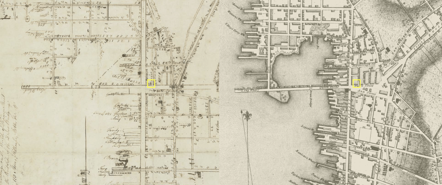
Without knowing the exact locations of the lands belonging to those mentioned, but knowing the location of the Common, and the fact that the highways included Spring Street and Thames Street, John’s parcel was likely contained in the land South and Southwest of Griffin (now Touro), West of Jews Street (now Bellevue), South to present Church Street or Mill Street, and West to Spring Street or Thames Street. The 1758 Ezra Stiles map of Newport is reasonably accurate East-to-West, but is shortened North-to-South, as if Ezra was tired when he paced it, or ran out of space on the paper. Long Wharf and the Streets off of Thames are also not at the perfect 90-degree angles as he drew them. John Rathbun’s principal business interests were in Newport, and he ultimately purchased a corner lot which had a house and a store at what is now 8 Washington Square. On the Stiles (1758) map below, he noted the store had a chimney and the two story house had two chimneys. The Blaskowitz (1777) map is more accurate cartography, including the extent of the harbor at that time, but the density of buildings doesn’t show the specifics of the house. The Rathbun buildings were some of the first encountered when coming or going from Long Wharf. It was, quite literally, the harborfront where the Common met Narragansett Bay. In 1702, John was listed as a proprietor of the town wharf in Newport.

John died in 1702, and Margaret outlived him by 14 years. In July 1707, she was listed as the owner of a lot in Newport. In March 1716, as the “widow and relick of John Rathbun, deceased,” she made a deposition on Block Island regarding property she and her husband had deeded to their son, John Rathbun, Jr. (1655-1723). John Jr. was admitted freeman of the Colony of Rhode Island May 1, 1684. He was 67 in 1722, a year before his death, when he sold the 8 Washington Square house to deputy governor and chief justice John Gardner. In 1793, Abraham R. Riviera bought the house and, in 1804, it became the Newport Bank, with its brick end walls added around 1950, as it stands today. A carved stone plaque on the clapboard still reads: “In this building then the residence of Deputy Governor John Gardner, the Rev. James Manning, in July 1763, met with interested citizens and first made the design known to establish a college in the English Colony of Rhode Island which became, in the year 1804, Brown University.”
Rathbun’s Copper Still & Newport Rum
The 1702 presence of a copper still in his house and shop in Newport, on the edge of the town wharf, is unique and telling. After the lilvestock, it’s the second item on the inventory in his will: “In the house at Newport – Coppur Still at three pounds.” With the introduction of sugarcane as a crop, rum was being distilled in Barbados by the mid 1640’s and in quantity in Rhode Island by 1684, when the earliest distillery is documented in Providence. In 1702, it is estimated that 10,292 gallons were exported from Rhode Island to Africa alone, and rum was the leading export from Rhode Island to other American colonies. By 1807, in the middle of the slave trade, Rhode Island’s rum exports to Africa totaled 10,980,724 gallons. This wasn’t mellow rum aged in wooden casks. Rather, it was freshly distilled overproof New England white rum for the “Guinea trade” on the coast of Africa, and The Gold Coast in particular. In addition to rum, Rhode Island merchants sent supplies south to Caribbean plantations, such as those from the farms of Richard Smith. A 1708 list in the Records of the Colony of Rhode Island and Providence Plantations shows commodities exported 1698-1703 included lumber (staves, hoops, board, plank, timber), beef, pork, butter, cheese, onions, horses, candles, cider, Indian corn, provisions, iron, wax and rum. This certainly included the output of Rathbun’s farms on Block Island and his husbandry of Brenton’s expansive 2,000-acre farm in Newport at Hammersmith which, at Brenton’s death in 1674, included 80 horses, 52 cattle and 1,500 sheep. The goods that returned from the Caribbean included sugar, flour, rice, salt, fabrics and, most importantly, molasses to distill into rum. Throughout the 1790’s, 28 separate distilleries were in business in Rhode Island at one time or another: 17 in Providence, 10 in Newport, and 1 in Bristol. The 1798 Newport tax list, in the commercial properties listed in schedule “E,” names and values the distilleries of Peleg Clark, George Gibbs, Archibald Curry, and John Whitehorne. These four businesses existed amongst countless buildings, dozens of wharfs, numerous rope walks and tanning yards, a sugar house and a whale oil house. Many of the commercial buildings could have had stills and produced rum, but not on the scale and weekly output to be noted as a distillery. The absence of records from the late 1600’s leaves the volume of Rathbun’s distillation unclear, but the presence of a copper still is confirmed and its product almost certain.
